Transportation Plan
Development plans include the construction of mass transit systems involving light rail lines, trains and busses at the expense of lanes for private cars

With regard to parking, the master plan recommends reducing the number of aboveground parking spaces for the benefit of campus development that includes gardens and future buildings, and concomitantly - to increase the total supply of parking spaces throughout the campus. According to the Urban Building Plan, at least 5,500 parking spaces are required or as the minimum required according to the parking standard - whichever is greater. According to the valid parking standard, the number of spaces is lower than the number defined in the UBP, and stands at 5,450 spaces according to the breakdown of uses, and 3,490 according to a general calculation on the basis of built up area. Therefore, the 5,500 figure is the obligatory number of parking spaces. With the maximum construction permitted by the UBP (354,000 sq.m. of primary construction) 5,700 parking spaces will be required according to the standard. In practice, as of 2016, there are presently 5,500 parking spaces in the University’s parking lots.
The transportation policies of the Tel Aviv-Jaffa municipality and the Ministry of Transport attempt to cope with urban traffic congestion and with parking and traffic problems in a way that is no different than that employed by other major metropolitan areas around the world facing similar problems. The main thrust of the policy: Encourage the use of public transport and non-motorized transportation and create difficulties and obstacles to the use of private cars and their entry into the city center. Development plans include the construction of mass transit systems involving light rail lines, trains and busses with exclusive right of way, at the expense of lanes for private cars, and the building of a system of bicycle paths. Until these plans can be completed (the first light rail line is expected to begin operating only in 2021), new plans have been drawn up for the bus transport system and exclusive lanes are being allocated for public transport along major arteries. A network of "park and ride" lots with fast traffic lanes (toll lanes) at the edges of the city encourage people to park outside of the business centers, promoting the combined use of private cars to the parking lot and public transport from the parking lot to and within the city. In order to prevent the overuse of private vehicles (which also leads to increased traffic violations and traffic congestion when looking for parking), there has been increased enforcement of traffic and parking laws using electronic means. The construction of large underground parking lots downtown aims to remove private cars from the surrounding narrow streets. A policy to encourage bike-riding and walking aims to use green transportation and alternatives to motorized vehicles. As part of this effort a network of bicycle paths and bike-rental facilities (Tel-o-Fun) was established and being developed. Along main arteries and boulevards attempts are being made to remove obstacles from the sidewalks (such as electricity poles and garbage bins) to make way for pedestrians and bicycle riders.
This policy fits in with the campus transportation plan. Tel Aviv University is located next to the "University-Convention Center" train station and the physical connection between the University and the station is vital to the continued rise in the number of people coming to the campus by train. The future light rail system Green Line is slated to travel along Levanon Street adjacent to the campus fence, and two stations (“Einstein” and “Broshim” campus) are planned to allow good access to the University. The bus system includes two end terminals near the campus (the eastern terminal adjacent to the train station, and the Klachkin terminal near the Goldrich Fitness Center). The University has also adopted the municipality’s policy of underground parking lots. The first such lot, the Miriam and Adolfo Smolarz Auditorium parking lot, has been open since 2008 and the Museums parking lot will be operational in 2017. Additional parking lots are also being planned to allow us to eliminate the aboveground parking lots, and these areas can be used as reserves for future campus development. Below are details regarding plans for each transportation sphere.
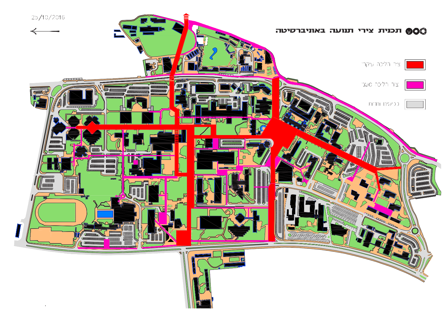
Buses
There are 13 bus lines that serve the campus from Tel Aviv and nearby cities. Bus traffic uses the road that goes around the campus. It appears that the number of bus stops, their location and distribution, reasonably addresses the demand in terms of walking distance and distances to the campus entry gates. Some of the lines travel on Levanon Street only, and others surround the campus and also serve George Wise, Klausner and Klachkin streets. Chaim Levanon Street is a broad urban street with four lanes of traffic (some of which are also used for parking), and therefore can regulate vehicular and pedestrian traffic, just like any other busy urban street, using traffic lights. With the addition of the light rail line and the future construction planned along the façade of the street, we can assume it will be necessary to give additional thought regarding the integration and arrangement of the different types of traffic along the street. On Klausner there is only one traffic lane in each direction with bays for parking and bus stops. There are large traffic jams at certain hours, mainly in the mornings and afternoons.
Activity along the street is concentrated in three areas: The area of Gate 14 - the Chella and Moise Safra gate and the Porter School of Environmental Studies building; the area of the Matatia Gate (Gate 2) and Steinhardt Museum of Natural History and Israel National Center for Biodiversity Studies; and the area near the Austria Gate (Gate 1) and the Center for Education Technology building. In addition to these centers there are fences along both sides of the street – the campus fence and the gardens fence. Rush hour traffic volumes and the fences on both sides of the road constitute a physical and mental buffer between the two parts of the campus. The University administration is trying to find a proper solution to create continuity between the two parts. In terms of the campus, the best solution would be to lower the roadway along the section between the Chella and Moise Safra Gate (14) and the Austria Gate (1) and remove the fences in this section – to create a single, contiguous campus. And while this solution is being looked into at this time, we can assume that due to its high cost it will be rejected, at least at this stage. Another solution (which is perhaps preferable for the city but less so for the campus) is to build a pedestrian bridge between the two parts of the campus and leave the road at its current elevation. The fear is that just like with many other pedestrian bridges built around the city that requires people to climb in order to cross over to the other side, the use of this bridge would be minimal. Ultimately, this is also only a partial solution and insufficient. The present plan does not offer a solution for this problem, other than major crosswalks at the three locations, on the assumption and with the hope that one day there will no longer be a security need for fences and the problem can be resolved in that way. As noted, the matter is being examined and will apparently be reflected in the future master plan.
The light rail
The Green Line of the light rail system is slated to travel down Einstein Street from the sea toward the campus, and will turn right onto Chaim Levanon Street near Sally and Lester Entin Square. The location of the light rail stop is planned near the Brender-Moss Library for Social Sciences, Management and Education, slightly to the south of Sally and Lester Entin Square so as not to interfere with the University’s plans to develop Chaim Levanon Street at that location. The University would prefer that the light rail line be moved to the center of Chaim Levanon street, thereby leaving the sidewalk on the eastern side clear and wide to enable urban and student activities, but the idea met with opposition from the light rail line planners. The already congested intersection of Einstein and Chaim Levanon streets, combined with the activities at Sally and Lester Entin Square and the student dorms, with the addition of the future planning of the light rail line and station and the University’s own plans to develop this area of Chaim Levanon Street, will undoubtedly require serious consideration and particular attention.
Parking
We have already mentioned the subject of the unaesthetic parking lots found throughout the campus and the plans to replace them in the future with underground parking. The plan shows two underground parking lots that already exist: the parking lot at the Miriam and Adolfo Smolarz Auditorium and the Museums parking lot (marked in green). Six additional parking lots are shown on the plan. Two of them (shown in orange) - the Engineering and dormitories parking lot and the Entin Square parking lot - are to begin construction soon. Four other lots (shown in red) are scheduled to be built later on in the future. Of these, the Klausner parking lot is actually a municipal lot, but due to its location within the area of the UBP (the blue line), we refer to it in the plan as a parking lot that will serve the campus.
The plan does not propose a significant increase in the number of parking spaces to be found in the parking lots beyond what can be found at the present time and what the UBP requires (around 5,500 spaces), based on the assumption that the development of public transportation – with the completion of the light rail line and making the Israel Railways train station more accessible – will enable a reduction in the number of private cars coming to the campus.
Israel Railways
Recently the southern cliff was developed and the "Science Promenade" was built which, among other things, connects the campus with the “University – Convention Center” train station of the Israel Railways national rail system. This connection has one section that has a steep incline include that bridges the topographical discrepancy between the station and the campus with 100 steps, which start at the western exit from the train station near the bus terminal. The intention is that soon an elevator and/or escalator will be built between the lowest level of the station and the higher elevation of the Science Promenade in order to make both levels more accessible. At the present, in addition to the stairs by which it is possible to reach the campus from the train station, there is a bus between the terminal and the campus.
Explore


